Contents
Index
Design File
When points are created or deleted in the job the actions are recorded in a design file.
This file recording can be enabled or disabled using the menu option Points/Point Settings.
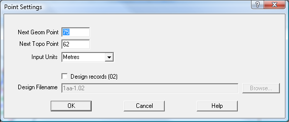
You can specify the design file name and location. For example if point 4 is defined using the
bearing distance option from point 111 on the same bearing as the line from points 229-104 and the distance between
points 104-111, this information is recorded on the design file. You can view and edit the design data using the
menu option Edit/Edit ACS File.
Thus you can see that it has recorded the point creation not as a simple bearing and distance but as a set of
relationships to existing points. So what use is all this?
The menu option Points/Reduce 02 Geom File will read the design file and use the design records to re-compute all the points.
For example, say the subdivision was designed using an offset from the road centreline to the lot boundaries of 10m.
You can then edit the design file and change the offset definition to say 9.5m and re-compute all the points.
See Reduce 02 Geom File
Geom Reduction Routines for more details.